KGIS News

KGIS News

2024 Aerials Now Available

Preliminary aerials for 2024 added to KGIS Maps

A new set of "preliminary" aerials from Winter 2024 have been added to KGIS Maps These aerials are a by-product of the oblique photography capture conducted by  EagleView\Pictometry (on behalf of the Knox County Property Assessor's office and KGIS). The more accurate version of these aerials will be made available later this year.

These 2024 aerials can be toggled on by selecting "2024 Aerial Preliminary" theme in the  "Historical Aerials" section of the Maps panel. ( The default "Aerial" map theme of KGIS Maps still reflects the 2022 vintage aerials.)

While the 2024 aerial image is an accurate representation of ground conditions (at the time taken), it has not been fully rectified and should ONLY be used with the following understanding:

  • The imagery has NOT been fully rectified to ground control and is not as accurate as a true orthophoto.
  • The imagery may have breaks, gaps, and other issues. This is especially true around elevated features such as bridges and overpasses.

2024 Aerial Oblique images are also available. Access them via the Launch...Pictometry tool in the blue command strip at the top of the KGIS Maps page.

Tuesday, April 9, 2024/Author: Bryan Lynn/Number of views (98)/Comments (0)/ Article rating: No rating
Categories: Public

2022 Aerials Now Available

Preliminary aerials for 2022 added to KGIS Maps

A new set of "preliminary" aerials from Spring 2022 have been added to KGIS Maps These aerials are a by-product of the oblique photography capture conducted by  EagleView\Pictometry (on behalf of the Knox County Property Assessor's office and KGIS). The more accurate version of these aerials will be made available later this year.

These 2022 aerials can be toggled on by selecting "2022 Aerial Preliminary" theme in the  "Historical Aerials" section of the Maps panel. ( The default "Aerial" map theme of KGIS Maps still reflects the 2020 vintage aerials.)

While the 2022 aerial image is an accurate representation of ground conditions (at the time taken), it has not been fully rectified and should ONLY be used with the following understanding:

  • The imagery has NOT been fully rectified to ground control and is not as accurate as a true orthophoto.
  • The imagery may have breaks, gaps, and other issues. This is especially true around elevated features such as bridges and overpasses.
  • Due to weather and ground conditions, the full project was acquired over a 2-3 month time period. Therefore, one will notice that some areas have more vegetatin than others.

2022 Aerial Oblique images are also available. Access them via the Launch...Pictometry tool in the blue command strip at the top of the KGIS Maps page.

Friday, July 8, 2022/Author: Keith G. Stump/Number of views (3434)/Comments (0)/ Article rating: 2.8
Categories: Public

TN House and Senate District Boundaries Updated

New "2022" boundaries are now the DEFAULT map on KGIS

The Tennessee State House and Senate district boundaries have been updated on the KGIS system to reflect the newly adopted "2022" boundaries as approved and signed into law in February of 2022. 
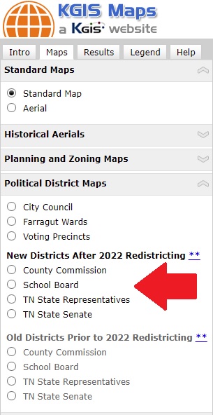
Every 10 years, the US Census Bureau conducts extensive population counts to ensure equal representation by government. If the updated population tallies reveal that some districts have significantly more or fewer people than the others, the district boundaries must be adjusted to rebalance the population. 

The various maps and reports on the KGIS website have all now been updated to display these newly adopted "2022" boundaries.  Any questions regarding one's state House or Senate representative should be directed to the State Comptroller's Office. (Click here to access the State's Re-districting dashboard). 

The new "2022" boundaries that display on the KGIS system are, to the best of our knowledge, the certified boundaries as provided to KGIS by the Knoxville-Knox County Planning department. It is KGIS's understanding that these new "2022" boundaries were based upon the US Census data, and are therefore dependent upon the accuracy and precision of those source map datasets. Users of the KGIS system should note that the boundaries do not always align with KGIS's basemap features, especially at the "zoomed in" levels.   

The following applications have all been updated to display/report using the new "2022" Districts: 

  • Voting Location Search
  • Parcel Map & Details Map
  • KGIS Maps: TN State Representative; TN State Senate Map themes
  • KGIS Maps: Parcel Identify...Get Full Parcel Details....Voting Information tab.
  • The Ready Made Maps:TN State House and TN State Senate maps

 For information on voting locations contact the Knox County Election Commission. (website).

Wednesday, March 2, 2022/Author: Keith G. Stump/Number of views (2423)/Comments (0)/ Article rating: 5.0
Categories: Public

County Commission and School Board District Boundaries Updated

New "2022" boundaries are now the DEFAULT map on KGIS

The County Commission and School Board district boundaries have been updated on the KGIS system to reflect the newly adopted "2022" boundaries as approved by Knox County Commission in October of 2021

Every 10 years, the US Census Bureau conducts extensive population counts to ensure equal representation by government. If the updated population tallies reveal that some districts have significantly more or fewer people than the others, the district boundaries must be adjusted to rebalance the population. 

The various maps and reports on the KGIS website have all now been updated to display these newly adopted "2022" boundaries.  Any questions regarding one's commissioner or School Board representative should be directed to the Knox County Commission. (website). 

The new "2022" boundaries that display on the KGIS system are, to the best of our knowledge, the certified boundaries as provided to KGIS by the Knoxville-Knox County Planning department. It is KGIS's understanding that these new "2022" boundaries were based upon the US Census data, and are therefore dependent upon the accuracy and precision of those source map datasets. Users of the KGIS system should note that the boundaries do not always align with KGIS's basemap features, especially at the "zoomed in" levels.   More information about the redistricting effort in Knox County can be found on the Knoxville-Knox County Planning website.

The following applications have all been updated to display/report using the new "2022" Districts: 

  • Voting Location Search
  • Parcel Map & Details Map
  • KGIS Maps: County Commission and School Board map themes
  • KGIS Maps: Parcel Identify...Get Full Parcel Details....Voting Information tab.
  • The Ready Made Maps: County Commission and School Board maps\

 For information on voting locations contact the Knox County Election Commission. (website).

Wednesday, February 16, 2022/Author: Keith G. Stump/Number of views (1924)/Comments (0)/ Article rating: 3.5
Categories: Public

Assessor introduces new Property Lookup website

Includes access to current Ownership, Sales History and Real Property details

The Knox County Property Assessor's office has introduced a new Property Lookup website that provides access to the latest collected real property information, including current ownership and related mailing addresses, past sales history, building sketches and other descriptive attributes. The site is integrated with KGIS Maps. 

Wednesday, November 10, 2021/Author: Keith G. Stump/Number of views (5112)/Comments (0)/ Article rating: 3.6
Categories: Public

TN unveils its Vaccine Finder WebSite

Interactive Map shows Health Dept and Pharmacies

The State of TN has unveiled its Vaccine Informaton web site, which includes an interactive Vaccine Finder map (Mapbox/OpenStreetMap-based) of locations where one can receive COVID vaccinations. Both Health Department - sponsored locations and other Pharmaceutical \ Clinic locations are identified on the map. More...

Friday, February 19, 2021/Author: Keith G. Stump/Number of views (1120)/Comments (0)/ Article rating: No rating
Categories: Public

KGIS welcomes Mr. Sean Kitts

GIS Analyst at KGIS

KGIS welcomes its newest staff member: Mr. Sean Kitts, who will serve as KGIS's primary GIS Analyst, and products generation specialist. Sean brings his prior geospatial experience of having worked in the Knox County Property Assessor's Office, and prior to that at Wiser & Company. He will oversee KGIS's provision of maps and GIS products to the public and to KGIS's partnership organizations. Sean earned his BA in Geography from the University of Tennessee. Sean can be reached by calling KGIS's main phone number of 865.215.2573. Or here is Sean's Email.

Tuesday, November 17, 2020/Author: Keith G. Stump/Number of views (845)/Comments (0)/ Article rating: 2.0
Categories: Public

What does an Address have to do with Taxes?

Informational Article posted on Knox Planning website

Knox Planning has posted an informational article onto its website about that department's maintenance of Addresses for all of Knox County. Click here to read the article.

Wednesday, July 29, 2020/Author: Keith G. Stump/Number of views (1178)/Comments (0)/ Article rating: 5.0
Categories: Public

State unveils COVID-19 Dashboard

Interactive graphs, maps and charts

The State of Tennessee's COVID-19 Unified Command has produced a GIS-based COVID-19 Dashboard that provides interactive access to statewide maps, data, graphs and charts related to the ongoing emergency. Different panels on the dashboard provide information related to the distribution of cases by county (and age), along with the geographical locations of Assessment (or testing) Sites across the state (including Knoxville and Knox County). Links to this and other COVID-related maps, including additional testing sites, can be found on KGIS's COVID-19 Maps & GIS page.

Thursday, April 30, 2020/Author: Keith G. Stump/Number of views (1070)/Comments (0)/ Article rating: No rating
Categories: Public

Public WiFi Locations added to the Map

new Theme added to COVID-19 Services Map

KGIS has created a new Public WiFi Theme in the COVID-19 Services & Resources Map showcasing those locations at which the public can gain access to free WiFi from the safe distance and comfort of their cars. As of April 22, 2020, there are six different sites available (all of which are at the Knox County Senior Centers). As more sites become available, KGIS will add those to this same map theme. Click HERE more information about the Knox County Senior Center WiFi access program. Note that the COVID-19 Services & Resources Map has several different "layers" (such as COVID testing sites), each of which can be toggled on/off (via the Map Layers panel...see image below). 


Wednesday, April 22, 2020/Author: Keith G. Stump/Number of views (1134)/Comments (0)/ Article rating: No rating
Categories: Public
1234567