KGIS News

KGIS News

2024 Aerials Now Available

Preliminary aerials for 2024 added to KGIS Maps

A new set of "preliminary" aerials from Winter 2024 have been added to KGIS Maps These aerials are a by-product of the oblique photography capture conducted by  EagleView\Pictometry (on behalf of the Knox County Property Assessor's office and KGIS). The more accurate version of these aerials will be made available later this year.

These 2024 aerials can be toggled on by selecting "2024 Aerial Preliminary" theme in the  "Historical Aerials" section of the Maps panel. ( The default "Aerial" map theme of KGIS Maps still reflects the 2022 vintage aerials.)

While the 2024 aerial image is an accurate representation of ground conditions (at the time taken), it has not been fully rectified and should ONLY be used with the following understanding:

  • The imagery has NOT been fully rectified to ground control and is not as accurate as a true orthophoto.
  • The imagery may have breaks, gaps, and other issues. This is especially true around elevated features such as bridges and overpasses.

2024 Aerial Oblique images are also available. Access them via the Launch...Pictometry tool in the blue command strip at the top of the KGIS Maps page.

Tuesday, April 9, 2024/Author: Bryan Lynn/Number of views (125)/Comments (0)/ Article rating: No rating
Categories: Public

2022 Aerials Now Available

Preliminary aerials for 2022 added to KGIS Maps

A new set of "preliminary" aerials from Spring 2022 have been added to KGIS Maps These aerials are a by-product of the oblique photography capture conducted by  EagleView\Pictometry (on behalf of the Knox County Property Assessor's office and KGIS). The more accurate version of these aerials will be made available later this year.

These 2022 aerials can be toggled on by selecting "2022 Aerial Preliminary" theme in the  "Historical Aerials" section of the Maps panel. ( The default "Aerial" map theme of KGIS Maps still reflects the 2020 vintage aerials.)

While the 2022 aerial image is an accurate representation of ground conditions (at the time taken), it has not been fully rectified and should ONLY be used with the following understanding:

  • The imagery has NOT been fully rectified to ground control and is not as accurate as a true orthophoto.
  • The imagery may have breaks, gaps, and other issues. This is especially true around elevated features such as bridges and overpasses.
  • Due to weather and ground conditions, the full project was acquired over a 2-3 month time period. Therefore, one will notice that some areas have more vegetatin than others.

2022 Aerial Oblique images are also available. Access them via the Launch...Pictometry tool in the blue command strip at the top of the KGIS Maps page.

Friday, July 8, 2022/Author: Keith G. Stump/Number of views (3445)/Comments (0)/ Article rating: 2.8
Categories: Public

State unveils COVID-19 Dashboard

Interactive graphs, maps and charts

The State of Tennessee's COVID-19 Unified Command has produced a GIS-based COVID-19 Dashboard that provides interactive access to statewide maps, data, graphs and charts related to the ongoing emergency. Different panels on the dashboard provide information related to the distribution of cases by county (and age), along with the geographical locations of Assessment (or testing) Sites across the state (including Knoxville and Knox County). Links to this and other COVID-related maps, including additional testing sites, can be found on KGIS's COVID-19 Maps & GIS page.

Thursday, April 30, 2020/Author: Keith G. Stump/Number of views (1071)/Comments (0)/ Article rating: No rating
Categories: Public

Public WiFi Locations added to the Map

new Theme added to COVID-19 Services Map

KGIS has created a new Public WiFi Theme in the COVID-19 Services & Resources Map showcasing those locations at which the public can gain access to free WiFi from the safe distance and comfort of their cars. As of April 22, 2020, there are six different sites available (all of which are at the Knox County Senior Centers). As more sites become available, KGIS will add those to this same map theme. Click HERE more information about the Knox County Senior Center WiFi access program. Note that the COVID-19 Services & Resources Map has several different "layers" (such as COVID testing sites), each of which can be toggled on/off (via the Map Layers panel...see image below). 


Wednesday, April 22, 2020/Author: Keith G. Stump/Number of views (1143)/Comments (0)/ Article rating: No rating
Categories: Public

KGIS introduces COVID-19 Services Map

Testing, Food Distribution and PPE Donation Sites

In partnership with the Knox County Health Department and KEMA, the KGIS Office has designed a COVID-19 Resources & Services Map to promote some of the available services (and resources) for citizens of Knoxville and Knox County during this pandemic emergency. KGIS relies upon information from other agencies and departments, but in particular upon the advise and counsel of the Knox County Health Department and the Knoxville Emergency Managament Agency (KEMA). KGIS welcomes any feedback regarding out-of-date or erroneous information presented on this site (Email us at kgis@kgis.org). 

The map currently shows four different service categories:  Appointment Only Testing, Youth Food Locations, PPE Donation Sites and Public WiFi Sites. Users of this interactive map might choose to visit the generic Services & Resources Map, or optionally, link directly to one of the specific categories (or "themes"). (see below hyperlinks). Each Theme "toggles" on/off layers of information to provide a more focused view of services on the map. As new service categories ("themes") are added to the map, KGIS will accordingly provide direct hyperlinks to those new themes.

Visit KGIS's COVID-19 GIS Maps & Resources page for more news and links to COVID-related GIS sites.  

Monday, April 13, 2020/Author: Keith G. Stump/Number of views (593)/Comments (0)/ Article rating: 4.0
Categories: Public

2019 Aerial Photos added to KGIS Maps

via the Maps..Historical Aerials theme

KGIS Maps has been updated with a new set of 2019 Aerial orthophotography from the Tennessee Department of Transportation (TDOT), which has a regular aerial update program that involves flying each region (of which there are four total) of the state at least once over a four (4) year period. Prior to this 2019 mission, TDOT most recently flew East Tennessee back in 2015.

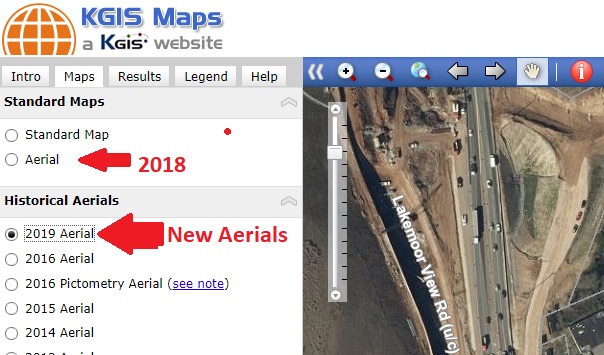
Since the resolution (of 1 foot) of the 2019 orthophotography is not quite as detailed as KGIS's standard 6" digital orthophoto aerials, KGIS has decided to NOT replace the default Aerial map with this newly updated 2019 aerial. (Note: The default Aerial map represents spring 2018 and was acquired at a 6" resolution). KGIS Maps users will instead access the 2019 aerials in the "Maps....Historical Aerials" section of KGIS Maps. (see image below). The 2019 aerial currently accessible in KGIS Maps covers only Knox County.

It should also be noted that KGIS expects to receive in May/June 2020 timeframe a new set of 6" resolution aerials covering all of Knox County and the extended KUB service area. Once that data has been finalized, the default Aerial theme of KGIS Maps will be updated.
 

Tuesday, March 31, 2020/Author: Keith G. Stump/Number of views (1175)/Comments (0)/ Article rating: 4.0
Categories: Public

COVID-19 Dashboard hosted by TN-SDC

Tennessee State Data Center

The Tennessee State Data Center (TNSDC) has created a COVID-19 Dashboard that presents information (and interactive maps) as compiled from daily updates from the Tennessee Department of Health. TNSDC is hosted at the UT Boyd Center for Business and Economic Research.

Thursday, March 26, 2020/Author: Keith G. Stump/Number of views (996)/Comments (0)/ Article rating: 5.0
Categories: Public

TEMA hosts map of PPE Donation Sites

Private Sector Donations of Personal Protection Equipment

The State of Tennessee's Emergency Management Agency (TEMA) has released an interactive map showing locations throughout the State at which donations of Personal Protection Equipment (PPEs) can be made. 

Thursday, March 26, 2020/Author: Keith G. Stump/Number of views (328)/Comments (0)/ Article rating: No rating
Categories: Public

State introduces a COVID-19 Cases and Assessment Sites Map

Interactive Maps and Data

The State of Tennessee's GIS Services department (within the Strategic Technology Solutions (STS) division) has developed an interactive map of the COVID-19 Cases and the Assessment Sites covering all the counties of the State, and as coordinated via the Tennessee State Department of Health. 

Tuesday, March 24, 2020/Author: Keith G. Stump/Number of views (310)/Comments (0)/ Article rating: No rating
Categories: Public

KGIS creates COVID-19 GIS Resources Page

Links and News about COVID-19-related map resources

KGIS has created a new COVID-19 Maps & GIS Resources page designed to provide access (and links) to various maps (and GIS resources) pertaining to the COVID-19 pandemic, and especially relevant to Knoxville and Knox County. The information gathered on this page comes from other publicly-accessible websites hosted by federal, state and local organizations. In general, KGIS relies upon the Knox County Health Department website for the latest, and most authoritative guidance. 

Monday, March 23, 2020/Author: Keith G. Stump/Number of views (246)/Comments (0)/ Article rating: No rating
Categories: Public
1234