KGIS News

KGIS News

2024 Aerials Now Available

Preliminary aerials for 2024 added to KGIS Maps

A new set of "preliminary" aerials from Winter 2024 have been added to KGIS Maps These aerials are a by-product of the oblique photography capture conducted by  EagleView\Pictometry (on behalf of the Knox County Property Assessor's office and KGIS). The more accurate version of these aerials will be made available later this year.

These 2024 aerials can be toggled on by selecting "2024 Aerial Preliminary" theme in the  "Historical Aerials" section of the Maps panel. ( The default "Aerial" map theme of KGIS Maps still reflects the 2022 vintage aerials.)

While the 2024 aerial image is an accurate representation of ground conditions (at the time taken), it has not been fully rectified and should ONLY be used with the following understanding:

  • The imagery has NOT been fully rectified to ground control and is not as accurate as a true orthophoto.
  • The imagery may have breaks, gaps, and other issues. This is especially true around elevated features such as bridges and overpasses.

2024 Aerial Oblique images are also available. Access them via the Launch...Pictometry tool in the blue command strip at the top of the KGIS Maps page.

Tuesday, April 9, 2024/Author: Bryan Lynn/Number of views (125)/Comments (0)/ Article rating: No rating
Categories: Public

2022 Aerials Now Available

Preliminary aerials for 2022 added to KGIS Maps

A new set of "preliminary" aerials from Spring 2022 have been added to KGIS Maps These aerials are a by-product of the oblique photography capture conducted by  EagleView\Pictometry (on behalf of the Knox County Property Assessor's office and KGIS). The more accurate version of these aerials will be made available later this year.

These 2022 aerials can be toggled on by selecting "2022 Aerial Preliminary" theme in the  "Historical Aerials" section of the Maps panel. ( The default "Aerial" map theme of KGIS Maps still reflects the 2020 vintage aerials.)

While the 2022 aerial image is an accurate representation of ground conditions (at the time taken), it has not been fully rectified and should ONLY be used with the following understanding:

  • The imagery has NOT been fully rectified to ground control and is not as accurate as a true orthophoto.
  • The imagery may have breaks, gaps, and other issues. This is especially true around elevated features such as bridges and overpasses.
  • Due to weather and ground conditions, the full project was acquired over a 2-3 month time period. Therefore, one will notice that some areas have more vegetatin than others.

2022 Aerial Oblique images are also available. Access them via the Launch...Pictometry tool in the blue command strip at the top of the KGIS Maps page.

Friday, July 8, 2022/Author: Keith G. Stump/Number of views (3445)/Comments (0)/ Article rating: 2.8
Categories: Public

2019 Aerial Photos added to KGIS Maps

via the Maps..Historical Aerials theme

KGIS Maps has been updated with a new set of 2019 Aerial orthophotography from the Tennessee Department of Transportation (TDOT), which has a regular aerial update program that involves flying each region (of which there are four total) of the state at least once over a four (4) year period. Prior to this 2019 mission, TDOT most recently flew East Tennessee back in 2015.

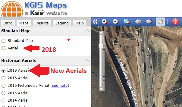
Since the resolution (of 1 foot) of the 2019 orthophotography is not quite as detailed as KGIS's standard 6" digital orthophoto aerials, KGIS has decided to NOT replace the default Aerial map with this newly updated 2019 aerial. (Note: The default Aerial map represents spring 2018 and was acquired at a 6" resolution). KGIS Maps users will instead access the 2019 aerials in the "Maps....Historical Aerials" section of KGIS Maps. (see image below). The 2019 aerial currently accessible in KGIS Maps covers only Knox County.

It should also be noted that KGIS expects to receive in May/June 2020 timeframe a new set of 6" resolution aerials covering all of Knox County and the extended KUB service area. Once that data has been finalized, the default Aerial theme of KGIS Maps will be updated.
 

Tuesday, March 31, 2020/Author: Keith G. Stump/Number of views (1175)/Comments (0)/ Article rating: 4.0
Categories: Public

KGIS receives the final 2016 Aerials

Available on KGISMaps, ArcMap, and Shared Folders

KGIS receives the final corrected 2016 Aerial Photography flown by The Atlantic Group, LLC back in March 2016.  Atlantic fixed a few issues and calibrated the color to remove some of the green and red color. These corrected aerials are available on all KGIS Mapping Applications, ESRI ArcMap Image Services, and TIFF images. 

Please contact KGIS at (865) 215-2641 if you have any questions or problems accessing the new aerials.


Thursday, August 3, 2017/Author: Chris Halcomb/Number of views (1669)/Comments (0)/ Article rating: 5.0
Categories: Public

Aerials now reflect Spring 2016 flight

KGIS Maps and other web-applications Updated

The Aerial map theme has been updated in KGIS Maps, and in other web-based sites such as City Survey Control, to reflect the recently flown 2016 ortho-photography (acquired from The Atlantic Group LLC). 

Previously, the Aerial theme had reflected spring 2014 vintage photography. To gain access to that original 2014 data, users can click on the 2014 Aerial theme located under the Historical Aerialscategory of Map themes (see image). READ MORE....

Tuesday, October 18, 2016/Author: SuperUser Account/Number of views (920)/Comments (0)/ Article rating: No rating
Categories: Public

Preliminary 2016 Aerial Theme added to KGIS Maps

Located under the Historical Aerials group

A new 2016 Aerial (Preliminary) map theme has been added to KGIS Maps. Since these aerials are preliminary, by-products of the Spring 2016 Knox County Property Assessor project with EagleView - Pictometry , they don't quite meet the product standards of past KGIS aerial products. Therefore, instead of replacing the default Aerial Theme (which is still vintage 2014), the preliminary aerials are located under the Historical Aerials category of Map themes (see image). READ MORE....

Thursday, May 26, 2016/Author: Keith G. Stump/Number of views (1834)/Comments (0)/ Article rating: 5.0
Categories: Public

2016 Aerial Images now visible via KGIS Maps

Updated 360° Oblique Photos from Pictometry

Newly acquired Spring 2016 oblique, 360° aerial imagery is now accessible to the KGIS Maps audience. Acquired in the Spring of 2016 by the Knox County Property Assessor,  the EagleView - Pictometry imagery provides a fresh, updated look at our ever-changing Knoxville and Knox County landscape. (For example, Click here to compare the 2016 and 2014 images of the redesigned Fort Dickerson Park entrance.). To access the....READ MORE

Thursday, April 21, 2016/Author: Keith G. Stump/Number of views (4517)/Comments (0)/ Article rating: 5.0
Categories: Public

Tips & Tricks: Oblique Imagery via KGIS Maps

How to Access Oblique Imagery

KGIS Maps Tip & Tricks: To access the oblique aerial imagery from KGIS Maps, one will want to use the Launch drop-down tool located on the blue toolbar  near the top of the screen. Click here for more information...

.

Monday, November 9, 2015/Author: Keith G. Stump/Number of views (2481)/Comments (0)/ Article rating: 3.5
Categories: Public